Late-Week Storm Will Cause Pre-Christmas Travel Delays in the East While a Series of Systems Will Impact the Northwest
By Jonathan Belles
An area of low pressure will spread widespread rain through the eastern states late this week.
At a Glance
A mainly rainy system will affect the eastern half of the country late this week.
Some snow could develop as colder air rushes in behind this storm.
Delays are likely for pre-Christmas travelers in the East late this week.
No major storm is on the horizon for the Christmas holiday.
Christmas travelers will likely encounter delays in the East late this week as a new storm system brings widespread rain – even thunderstorms for some – but relatively little snow.
More than 110 million people are forecast to take to the roads and air this holiday season, according to AAA. Thursday was expected to be the busiest travel day of the season this year.
Many Eastern cities will, unfortunately, see another soaking into Friday, slowing down drivers and flyers during the busiest of travel days.
Fortunately, there is some better news closer to Christmas. Let's lay out the daily forecast details as we know them right now. These forecasts may change, so check back with us for updates.
Daily Forecast
Friday
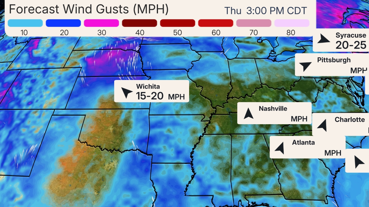
East: A low-pressure system will move into the Northeast. Rain, heavy at times, gusty winds and even some thunderstorms are likely in the Northeast, with rain showers and wind wrapping around the low in the eastern Great Lakes, Ohio Valley and Southeast. Some wet snow may occur over parts of northern Maine and the Great Lakes, and rain may change to wet snow Friday night in the Ohio Valley, eastern Great Lakes and Appalachians.
Central: Light snow and rain are possible in parts of the Dakotas and Minnesota. The rest of the Plains will remain dry.
West: A few mountain snow showers and valley rain showers are possible in the Northwest, Northern California, the northern and central Rockies and into northern Utah. Dry conditions are forecast to prevail elsewhere.
Travel Issues:
Airport Weather Delays Possible: Atlanta (early), New York, Boston, Philadelphia, Miami, Tampa
Interstates Possibly Affected: I-40 from North Carolina to Tennessee (rain showers, mountain snow showers), I-70 from Baltimore to Indianapolis (rain, changing to snow late in the Ohio Valley), I-75 from northern Georgia to Michigan (rain for most, some wet snow from Tennessee northward) and in Florida (wind), I-80 from New York to Indiana (rain, changing to wet snow late in the southern Great Lakes), I-95 north of Washington D.C. to Maine (rain)
Friday's Forecast
(The green shadings depict where rain is expected. Areas that are shaded blue are expected to see snow. Purple-shaded locations may see either rain or snow. Areas in pink are expected to see sleet or freezing rain (ice).)
Saturday
East: The storm system will finally move into eastern Canada, but rain showers may persist early in New England. Snow showers and wind may linger in the mountains of northern New England, upstate New York and the higher elevations of West Virginia and western Pennsylvania. Dry weather is expected elsewhere.
Central: A weak system may spread a few flakes in parts of the northern Plains or upper Midwest, but otherwise, dry conditions are expected to prevail.
West: A new storm system may arrive in the Pacific Northwest, with coastal rain and mountain snow. Some light snow is possible in parts of the central Rockies and adjacent Front Range.
Travel Issues:
Airport Weather Delays Possible: New York (JFK, LGA, EWR) may see delays from crosswinds
Interstates Possibly Affected: I-5 from Washington through Oregon (rain)
Saturday's Forecast
(The green shadings depict where rain is expected. Areas that are shaded blue are expected to see snow. Purple-shaded locations may see either rain or snow. Areas in pink are expected to see sleet or freezing rain (ice).)
Sunday
East: Light snow is possible from parts of the Midwest into the interior Northeast from the next system as it tracks eastward. Rain showers are expected farther south from the Ohio Valley into the South.
West: Rain is likely in the Pacific Northwest and parts of Northern California, with snow spreading from the Cascades and Sierra into the Great Basin and northern Rockies.
Travel Issues:
Airport Weather Delays Possible: San Francisco (low clouds), Seattle (rain)
Interstates Possibly Affected: I-5 from Washington through Northern California, I-90 from New York to Indiana,I-90 from Washington to Montana (mountain snow, valley rain)
Sunday's Forecast
(The green shadings depict where rain is expected. Areas that are shaded blue are expected to see snow. Purple-shaded locations may see either rain or snow. Areas in pink are expected to see sleet or freezing rain (ice).)
Christmas Eve (Monday)
East: High pressure looks to be in control, keeping the East mainly dry. The only exception may be some lake-effect snow showers in upstate New York downwind of lakes Ontario and Erie.
Central: Most of the central states should stay dry. However, some light snow is possible in parts of the upper Mississippi Valley while a few rain showers can't be ruled out along the northern Gulf Coast.
West: Mountain snow and low-elevation rain are expected from Washington state to Northern California, possibly spreading into Southern California late. Snow may be heavy in parts of the Sierra and Cascades, with snow possible even in some lower elevations. Some snow is also possible in parts of the Rockies and Great Basin.
Interstates Possibly Affected: I-5 from Washington through Northern California (rain), I-80 from the Bay Area into Nevada (mountain snow, Northern California rain)
Christmas Eve Forecast
(The green shadings depict where rain is expected. Areas that are shaded blue are expected to see snow. Purple-shaded locations may see either rain or snow. Areas in pink are expected to see sleet or freezing rain (ice).)
Christmas Day (Tuesday)
East: Our forecast guidance isn't yet in sync on the details, so this forecast may change, but mainly dry conditions are expected. A few pockets of light snow or a rain-and-snow mixture may develop late Tuesday in the Appalachians and Ohio Valley.
Central: Rain is possible in parts of the southern and central Plains, and a few patchy areas of snow are possible in the Great Lakes, Midwest and northern Plains.
West: Mountain snow appears to be a good bet in most higher elevations from the Rockies to the Sierra and Cascades, with low snow levels bringing snow to some lower elevations of the Great Basin. Otherwise, valley rain showers are possible from the Pacific Northwest to California, perhaps even the L.A. Basin.
Travel Issues:
Airport Weather Delays Possible: Dallas, Salt Lake City, San Francisco
Interstates Possibly Affected: I-5 from Washington through California (rain, mountain snow showers), I-35 from Texas to Iowa (rain showers), I-70 from Ohio to Utah (rain and snow showers), I-80 from the Bay Area into Utah (mountain snow, California low-elevation rain showers)
Christmas Day Forecast
(The green shadings depict where rain is expected. Areas that are shaded blue are expected to see snow. Purple-shaded locations may see either rain or snow. Areas in pink are expected to see sleet or freezing rain (ice).)
A potent low-pressure system is expected to intensify in the Plains after Christmas, but it is too early for details at this time.


No comments:
Post a Comment