What Is a Polar Vortex? The Frigid Weather Pattern Explained
The wintry weather pattern is back again, threatening to hit the U.S. with an especially bitter winter in 2019.
By David Grossman
GETTY IMAGES/SCOTT OLSON
Among the terms used to describe wintery weather, among the most dreaded is “polar vortex.” The ominous-sounding term sounds like some earthly black hole trying to kill us with Arctic air. It started appearing in weather forecasts more frequently this decade, especially after the polar vortex of 2014 that froze out Chicago and the Midwest.
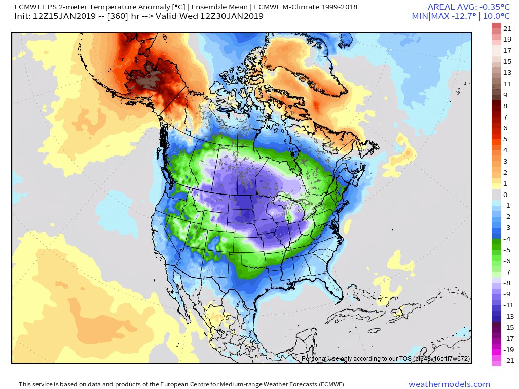
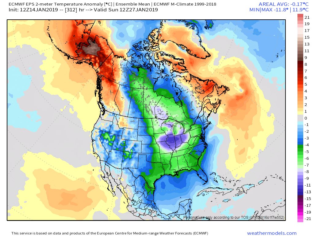
Now it's back. The polar vortex hovering above the Arctic has shattered into three parts, and it’s looking like the central and eastern United States will be in for some brutally cold weather in the next week. So what exactly is a polar vortex, and why do we keep hearing about it year after year?

End of January into early February. Cold. Really, really cold.
Frigid Cyclones
The term “polar vortex” has been used as far back as 1853, but names for the phenomenon shifted when scientists began to study it in earnest in the 20th century. The term was revised in 1950, when it was called a “circumpolar vortex,” then back to “polar vortex” by 1959. The American Meteorological Society glossary revised the definition in 2000, 2014, and then again in 2015.
The reason these changes keep happening is that the term “polar vortex” actually describes two types of cold weather events. One happens in the troposphere, the lowest layer of the earth’s atmosphere, while another happens higher up in the stratosphere. Basically it's a frigid cyclone.
Let's start with what they have in common. Both kinds of polar vortex are large-scale weather patterns dominated by "westerlies"—winds moving from west to east, encircling the polar region. The polar vortices found in the troposphere are generally much larger than the ones in the stratosphere and are usually the ones that effect weather down on the ground, chilling our bones here on the planet's surface.
Those winds swirling from west to east form a low-pressure system. That much is perfectly normal. These big swirling air masses normally hover over the North and South poles in the wintertime. In the northern hemisphere, polar vortices center around northeastern Siberia and Baffin Island in Canada, where winds spin counterclockwise around a low-pressure center at speeds of up to 100 miles per hour. A strong low-pressure system at the polar vortex keeps jet streams flowing across the planet.

In 2014, the infamous polar vortex put Chicago into a deep-freeze.
GETTY IMAGES/RAYMOND BOYD
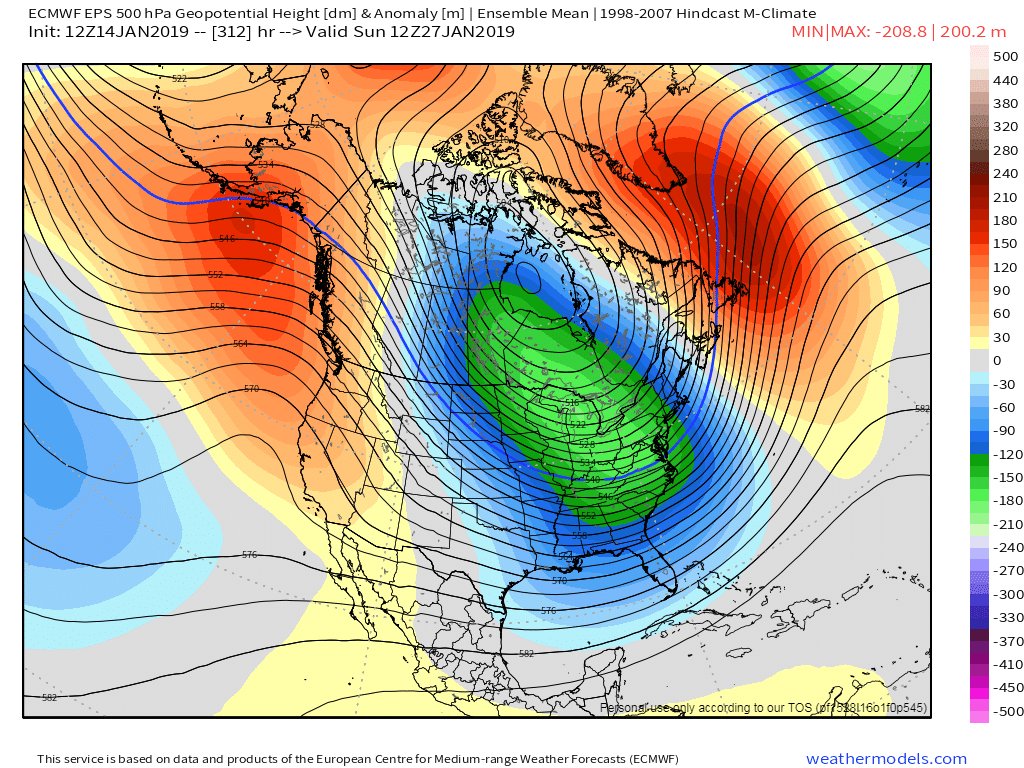
When the low-pressure system starts to weaken, though, that’s when people should start bundling up. Without a strong low-pressure system in place to maintain typical weather patterns, the jet stream starts to move around the earth. The wind begins to shift. Instead of a west-to-east trajectory, the jet stream starts to follow more of a north-to-south path. If that jet stream should encounter a high-pressure system, full of dry light winds, that can act as a choke point for the vortex. The system can break off and float southbound, right down to the United States.
That’s what happened in the infamous polar vortex of 2014. A tremendous high-pressure system over Greenland allowed for the jet stream to move south with a vortex in tow. Anybody who experienced the brutal weather, felt especially in the Chicagoland metropolitan area, had to live through temperatures in the negative teens Fahrenheit, the lowest in 20 years. In rural North Dakota, temperatures hit minus 22 F with a minus-50-degree wind chill.


Very strong and sustainable cold period setting up for most of North America late January through at least early February. Similar setup to extreme cold in Jan/Feb 2014 and 2015.
A Familiar Culprit
The same thing is coming around again. About New Year’s Day 2019, a stratospheric polar vortex began to fracture in the Arctic. Scientists suspect that recent weather events, including the snowstorm that hit Washington, D.C., are just the beginning of the polar vortex’s freezing reign.
But if polar vortices are normal, then why have they only recently become a big deal in the weather forecast? You can thank climate change.
Climate scientists have found "robust relationships" between Arctic warming and jet-stream wavering. In 2015, they predicted that “the frequency of extreme weather events caused by persistent jet-stream patterns will increase.”
So even when the weather is cold, climate change probably plays a leading role—and this chilly problem isn't going away.
No comments:
Post a Comment